The information on this page was initially collected to serve a 'LADM
and InfraGML' teleconference Feb. 28.
The information was later supplemented, but the scope is still to serve
as a basis for future LADM and InfraGML teleconferences (next April
3rd), for the invited 'Land Use Policy'-paper: 'Alignment of Standards
through Semantic Tools - The Case of Land Administration', and also for
the below mentioned parallel revisions, specifically of LandInfra.
The draft Land Use Policy paper includes the following sections, which
are commented upon below.
4. Thesaurus development:
1. CaLAThe hosting on general semantic platform
replaced by hosting at the OGC Definition Server
5. Motivating next steps:
1. The Land Administration scope: Parallel revisions
of LADM and LandInfra
2. The cross-domain scope, including linkages to
other structured, but non-geospatial data.
Content
- CaLAThe, the Cadastre and Land
Administration
Thesaurus
- SKOS, Simple Knowledge Organization System,
which support the use of knowledge organization systems (KOS) such as
thesauri, ..
- Code lists
- LandInfra/InfraGML
- Comparing
draft LandInfra with other standards (Boulder 2015)
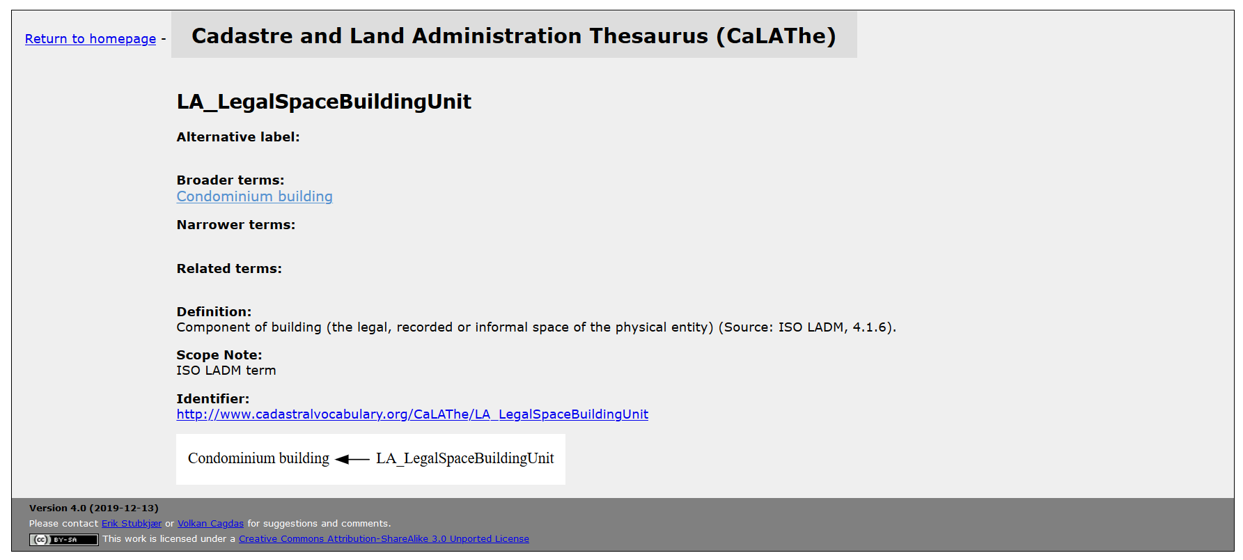
The acronym CaLAThe refers to the Cadastre and Land Administration
Thesaurus, which is available at http://cadastralvocabulary.org.
The thesaurus comprises terms from both LADM and LandInfra, and is
enhanced through visualization of term hierarchies, cf. the example on
Land below.
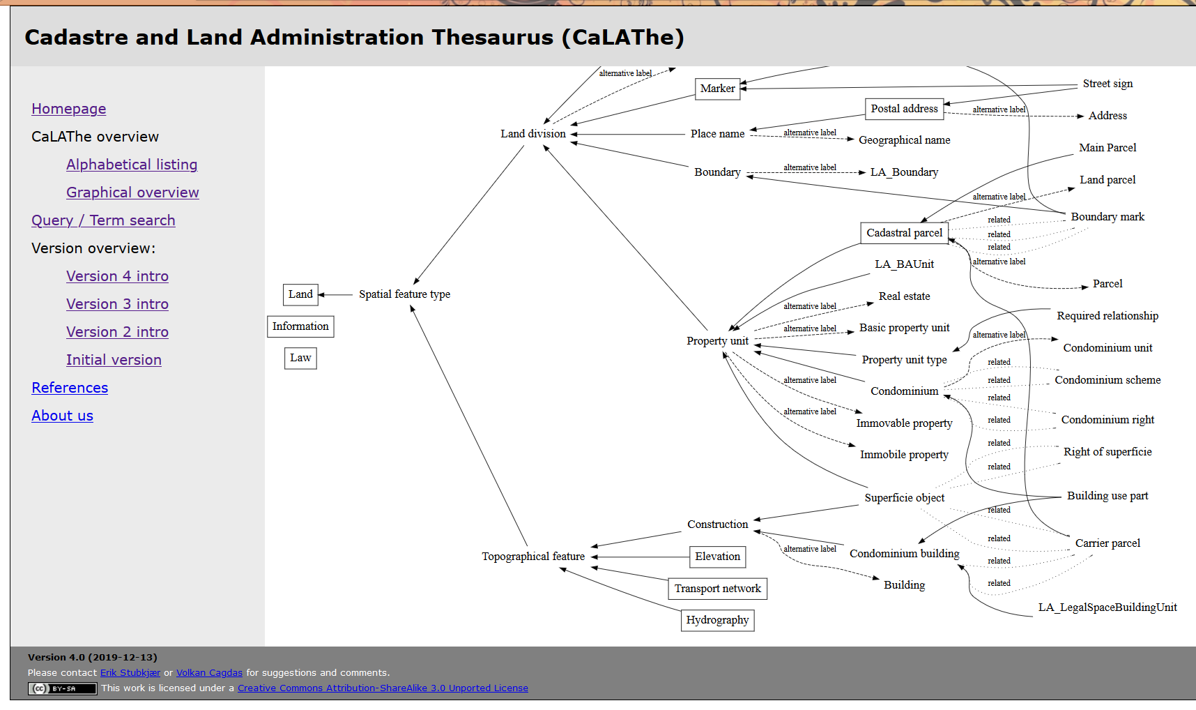
Searching for e.g. Surveyor illustrates, how the term is qualified
differently in LADM (marked with LA_) and in LandInfra (marked with
LI_), and thus facilitates alignment discussions.
CaLAThe is available not only through http://cadastralvocabulary.org,
but also through the Bartoc Skosmos tool. CaLAThe is presented among
social science vocabularies at http://bartoc-skosmos.unibas.ch/CaLAThe/en/,
thereby providing acces to controlled vocabularies outside the
geospatial domain.
Finally, CaLAThe is available through the Definitions Server of the OGC
at CaLAThe/4.0/. For example, the search
https://defs.opengis.net/elda-common/ogc-def/concept?labelcontains=condominium
renders the following 11 terms, (edited to occupy less space).
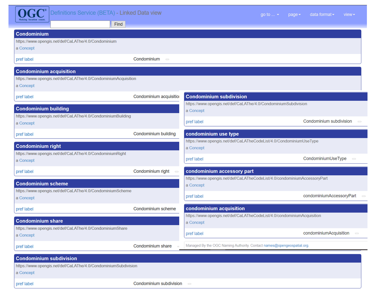
The individual concepts are further described with broader and narrower
concepts, if available. Next the term Building use part is rendered:
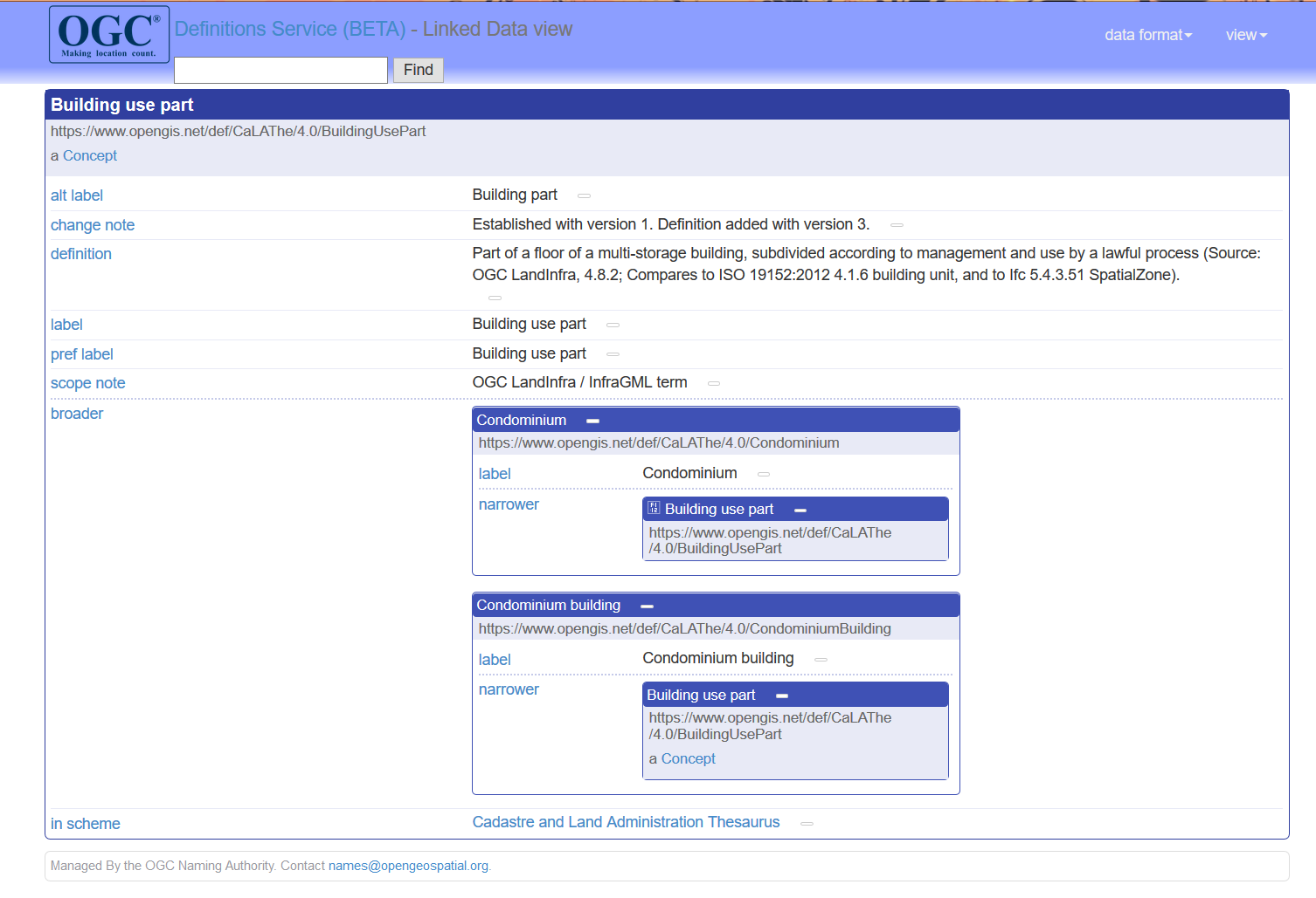
SKOS
CaLAThe is communicated to Bartoc and to the Definitions Server in
terms of the W3C-recommendation on SKOS. CaLAThe in SKOS format
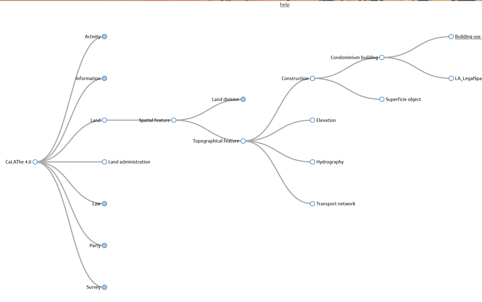
is available, and may be visualized also through
http://labs.sparna.fr/skos-play/. The following example illustrates
the location of the Building use part in the concept hierarchy:
(The text label is cut off; similarly, LA_LegalSpa should read:
LA_LegalSpaceBuildingUnit), cf. following figure.
Code lists
The most recent version (4.0) of CaLAThe also includes
code lists from parts of LandInfra, and a few of LADM. These code
lists, their names and values, are best visualized through http://labs.sparna.fr/skos-play/.
They are stored in the Concept scheme CaLATheCodelist, while the
ordinary elements are recorded in the Concept scheme CaLAThe. SKOS Play
thus offers a choice:
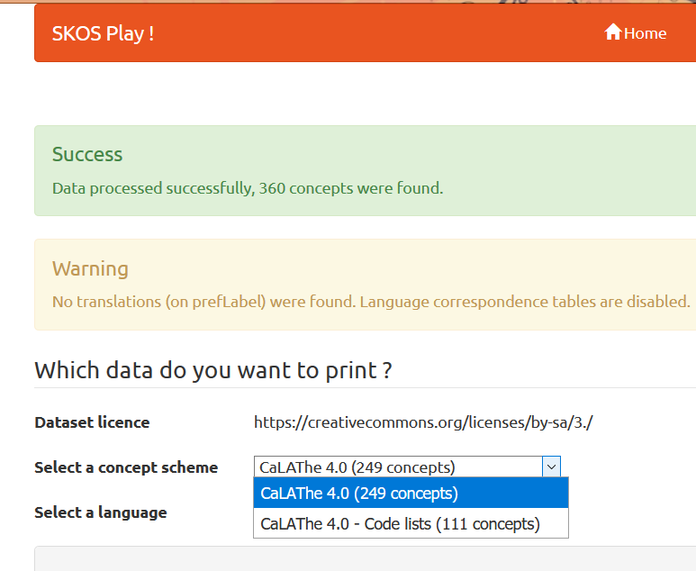
namely between CaLAThe 4.0 with 249 concepts, and CaLAThe 4.0 - Code
lists with 111 concepts.
CaLAThe code list 'members': Code list names and values, are also
available
from
https://defs.opengis.net/elda-common/ogc-def/resource?uri=https://www.opengis.net/def/CaLATheCodeList/4.0/&_format=html
LandInfra/InfraGML
OGC LandInfra/InfraGML is available from https://www.ogc.org/standards/infragml
The standards were developed during 2015-2017, reflecting the then
missing update of LandXML
The
cadastral part of LandInfra came in as a necessity, as infrastructure
projects, roads and railways, etc, change land ownership and
boundaries. Yet, the LandInfra
conceptual model standard in sections 7.10 and 7.11 covers
cadastral issues in terms of property units, cadastral parcels,
easements and condominiums.
The InfraGML Part 7 - Land Division
encoding standard includes in section B3
an example of the establishment of condominium
units. The concerned
.xml-file is rendered in InfraGML, but unfortunately, the corresponding
.xsl-file
is not included in the standard's example. However, the mentioned files are
available here:
Ex1: Part7CondominiumExample
A revised version of the above Ex1 is made. The content of the xml-file
is
strictly validated, and a detail in the xsl-file, regarding rendering
of parcel id, is
corrected
Ex1A: Part7CondominiumExample2103. The .xml file is transformed to .html by means of the .xsl file CondominiumExample2103.xsl. The .xml file is validated by means of Altova XMLSpy.
Due to the infrastructure focus of LandInfra/InfraGML, it was out of
scope to
relate specifications to the information systems applied by the
authority in charge of the cadastre. Therefore, LandInfra/InfraGML
intend to specify the information
sets, which articulates the intended cadastral change, as observed by
the licensed surveyor. These information sets
include existing property units, existing cadastral parcels, temporary
parts of cadastral parcels, new/applied for cadastral parcels, and
new/applied for property units. LandInfra moreover specifies the
corresponding property boundaries with hedges and boundary marks, and
finally the requested information on right of way or similar land-use
restrictions.
Ex2: Cadastral Account Documents
illustrates the
information sets by means of three documents: A schematic account of
cadastral changes, a coordinate list with point details, and a sort of
copy of a cadastral map, showing the present and the intended state of
boundaries and units. The main content of the documents (without
signatures, etc) is rendered in one .xml-file, which is transformed
into .html by means of the .xsl-file CadastralAccountExample0608.xsl. The information provided has to become interfaced with
the national information systems, but this should be pretty simple, as
information is specified according to the xml format.
Nødebo presentations, 2017
As the LandInfra standard was issued in 2016 and the InfraGML in 2017,
their implementation were advocated at a QGIS
user conference, August
2. – 11. 2017 in Nødebo, Denmark.
A background paper provides an introduction to the domain: QGIS for
Cadastral Management.
OGC contribution towards standardisation in the Land Administration domain is reported here.
Comparing draft LandInfra
with other standards (Boulder 2015)
At the outset of engagement in the LandInfra standardisation effort, I
presented the following material:
Source:
(OGC)Technical
Committee* Meetings 2015
Meetings 2015
Boulder GIS-BIM
Workshop [for OGC members only]
Jacynthe Pouliot et al (2019) How to quickly detect the overlap and the consistency
between LADM with LandInfra and LandXML: Application of schema matching
techniques referred to it and thus motivated me to make it public
available in its draft form.
Erik Stubkjær, est@land.aau.dk,
2020-07-17; 04-06, -04; 03-14; 02-27